QGIS Plugin for Loading Basemap
Published Date: Oct. 14, 2024, 7:52 a.m. || Abin Prajapti 456 views
This is a plugin to load OSM and satellite imagery in QGIS.
All code related to this plugin is freely available in github.
Methods used in this plugin
- __init__(self,iface):
This method initializes the plugin with the QGIS interface.
- initGui(self):
This method sets up the graphical user interface for the plugin. It creates an action with an icon that, when clicked, triggers the run method.
- unload(self):
This method removes the action form the toolbar when the plugin is unloaded and cleans up by deleting the action.
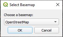
- run(self):
This method prompts the user with a dialog to choose between two basemap options: OSM or Satellite and it calls the appropriate method based on the user's selection to load the chosen basemap.
- load_osm(self):
It defines the url template for the OSM tiles and sets the minimum and maximum zoom levels and add rasterlayer using the add_basemap_layer method.
- load_satellite(self):
It defines the url template for the Google satellite tiles and sets the minimum and maximum zoom levels and add rasterlayer using the add_basemap_layer method.
- add_basemap_layer(self,rlayer,name):
It adds the layer to the QGIS project and inserts the layer at the bottom of the layer tree.
Main code
import os
import inspect
import requests
from PyQt5.QtWidgets import QAction, QInputDialog
from PyQt5.QtGui import QIcon
from qgis.core import QgsRasterLayer, QgsProject
cmd_folder = os.path.split(inspect.getfile(inspect.currentframe()))[0]
class BasemapLoaderPlugin:
def __init__(self, iface):
self.iface = iface
def initGui(self):
icon = os.path.join(os.path.join(cmd_folder, 'logo.png'))
self.action = QAction(QIcon(icon), 'Load Basemap', self.iface.mainWindow())
self.iface.addToolBarIcon(self.action)
self.action.triggered.connect(self.run)
def unload(self):
self.iface.removeToolBarIcon(self.action)
del self.action
def run(self):
# Let user choose which basemap to load
basemap_choices = ['OpenStreetMap', 'Satellite']
choice, ok = QInputDialog.getItem(self.iface.mainWindow(), 'Select Basemap', 'Choose a basemap:', basemap_choices, 0, False)
if ok and choice:
if choice == 'OpenStreetMap':
self.load_osm()
elif choice == 'Satellite':
self.load_satellite()
def load_osm(self):
basemap_url = 'https://tile.openstreetmap.org/{z}/{x}/{y}.png'
zmin = 0
zmax = 19
crs = 'EPSG:3857'
uri = f'type=xyz&url={basemap_url}&zmax={zmax}&zmin={zmin}&crs={crs}'
rlayer = QgsRasterLayer(uri, 'OpenStreetMap', 'wms')
self.add_basemap_layer(rlayer, 'OpenStreetMap')
def load_satellite(self):
# Load TMS layer (Google Satellite)
service_url = "mt1.google.com/vt/lyrs=s&x={x}&y={y}&z={z}"
zmin = 0
zmax = 19
crs = 'EPSG:3857'
service_uri = "type=xyz&zmin=0&zmax=21&url=https://" + requests.utils.quote(service_url)
tms_layer = QgsRasterLayer(service_uri, "Satellite Imagery", "wms")
self.add_basemap_layer(tms_layer, 'Satellite Imagery')
def add_basemap_layer(self, rlayer, name):
if rlayer.isValid():
# Add the layer, but not to the legend
QgsProject.instance().addMapLayer(rlayer, False)
# Insert layer at the bottom of Layer Tree
root = QgsProject.instance().layerTreeRoot()
position = len(root.children())
root.insertLayer(position, rlayer)
self.iface.messageBar().pushSuccess('Success', f'{name} Layer Loaded')
else:
self.iface.messageBar().pushCritical('Error', f'Invalid {name} Layer')
Geospatial Category
Recent Posts